Identificatie
referentie code
Titel
Datum(s)
- 1937-05-22 (Vervaardig)
Beschrijvingsniveau
Omvang en medium
1 page
Context
Naam van de archiefvormer
archiefbewaarplaats
Geschiedenis van het archief
Directe bron van verwerving of overbrenging
Inhoud en structuur
Bereik en inhoud
SUMMARY:
The diarist describes Dungshinggang (the Black Mountain), explains the local meaning of its name, notes a nearby shrine to a mountain god, and records bird sightings. On 20th May they travelled about 3½ miles to Gnüdulakh on the north side of Dungshinggang, with clearing weather, views of the Punsum peaks, photographs, and a bearing taken from camp at Wangchelakh.
CONTENT:
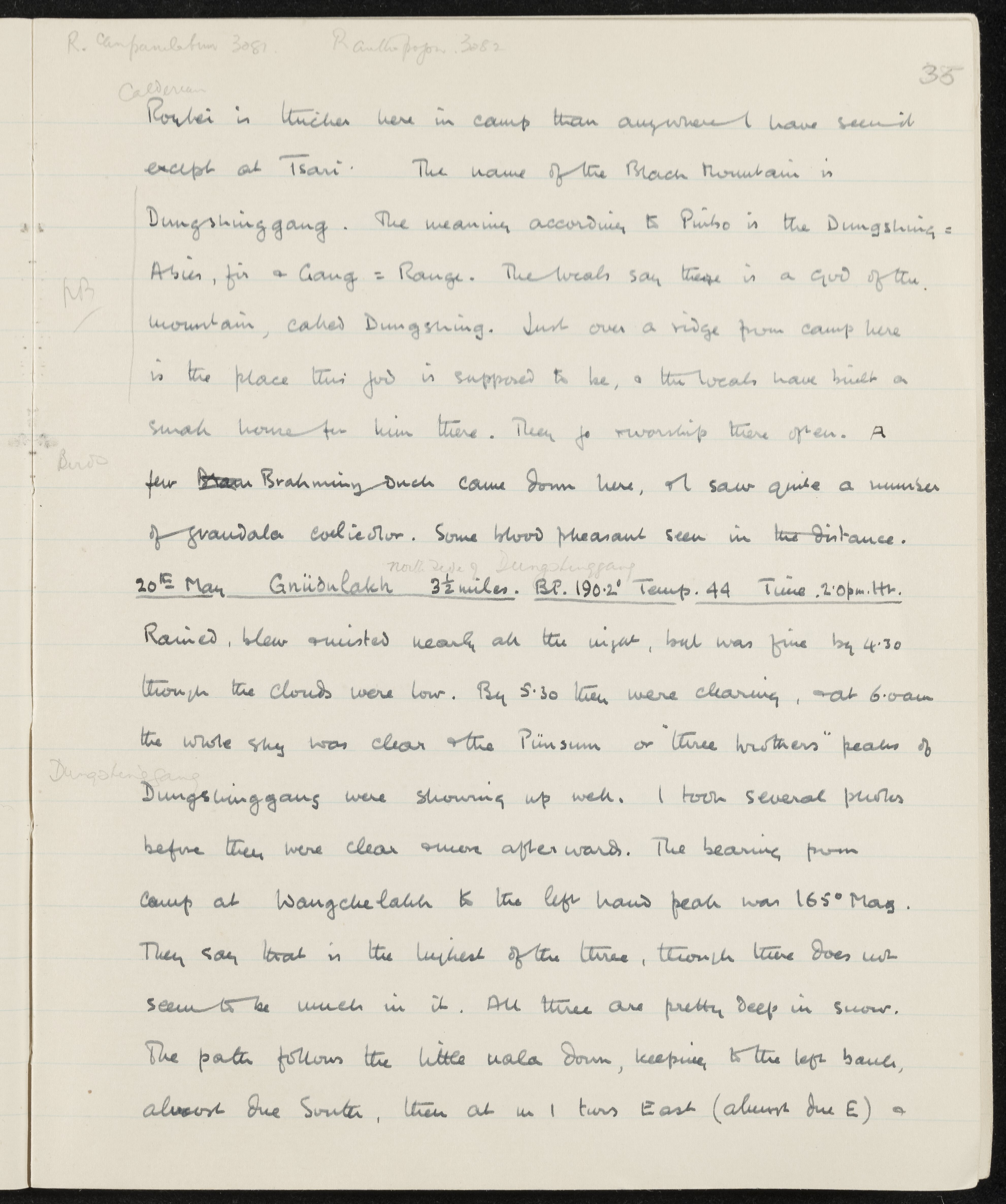
R. Campanulatum 3081 R. anthopogon 3082 35
Hookeri is thicker here in camp than anywhere I have seen it except at Tsari. The name of the Black Mountain is Dungshinggang. The meaning according to Punso is the Dungshing = Abies, fir and Gang = Range. The locals say there is a god of the mountain, called Dungshing. Just over a ridge from camp here is the place this god is supposed to be, and the locals have built a small house for him there. They go to worship there often. A few Brahminy Duck came down here, and I saw quite a number of Grandala coelicolor. Some blood pheasant seen in the distance.
20th May Gnüdulakh 3 1/2 miles. BP. 190.2' Temp. 44 Time 2.0pm. Hr.
(North side of Dungshinggang)
Rained, blew and misted nearly all the night, but was fine by 4.30 though the clouds were low. By 5.30 they were clearing, and at 6.0am the whole sky was clear and the Punsum or "three brothers" peaks of Dungshinggang were showing up well. I took several photos before they were clear and more afterwards. The bearing from camp at Wangchelakh to the left hand peak was 165° Mag. They say that is the highest of the three, though there does not seem to be much in it. All three are pretty deep in snow. The path follows the little nala down, keeping to the left bank, almost due South, then at m 1 turns East (always due E) and
Waardering, vernietiging en slectie
Aanvullingen
Ordeningstelsel
Voorwaarden voor toegang en gebruik
Voorwaarden voor raadpleging
Voorwaarden voor reproductie
Taal van het materiaal
Schrift van het materiaal
Taal en schrift aantekeningen
Fysieke eigenschappen en technische eisen
Toegangen
Verwante materialen
Bestaan en verblifplaats van originelen
Bestaan en verblijfplaats van kopieën
Related units of description
Aantekeningen
Alternative identifier(s)
Trefwoorden
Onderwerp trefwoord
Geografische trefwoorden
Naam ontsluitingsterm
- Grandala coelicolor (Onderwerp)
- R. anthopogon (Onderwerp)
- R. campanulatum (Onderwerp)