Área de identidad
Código de referencia
Título
Fecha(s)
- 1933-07-05 (Criação)
Nivel de descripción
Volumen y soporte
1 page
Área de contexto
Nombre del productor
Institución archivística
Historia archivística
Origen del ingreso o transferencia
Área de contenido y estructura
Alcance y contenido
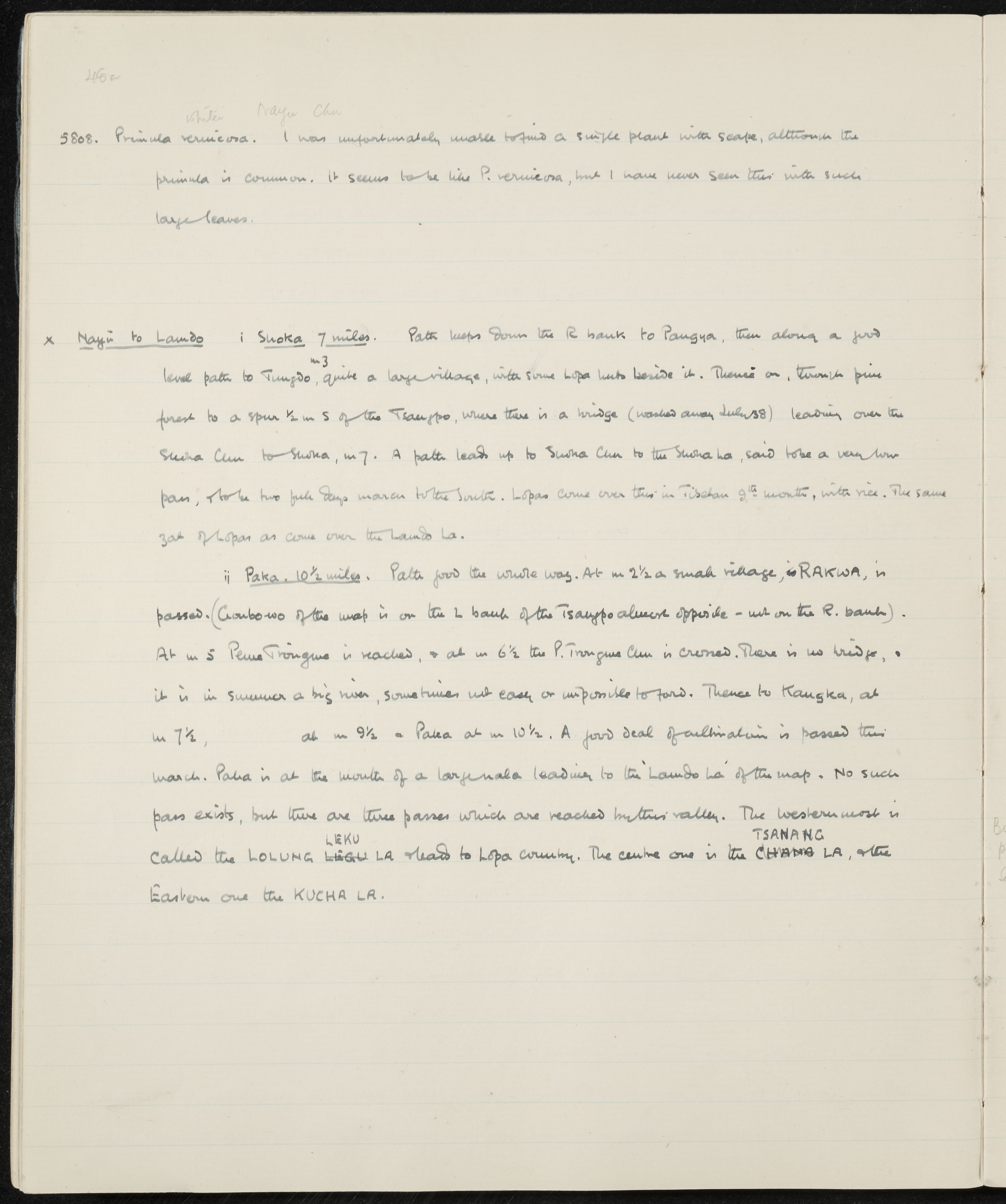
SUMMARY:
Notes an observation of Primula vernicosa lacking scapes despite being common. Describes routes from Nayu along the Tsangpo to Suoka (via Pangya and Tungdo) and onward to Paka (via Rakwa, Pema Trongmo, the P. Trongmo Chu, and Kangka), including bridge conditions and nearby passes (Lolung Leku La, Tsanang La, Kucha La).
CONTENT:
245a
White Nayu Chu
- Primula vernicosa. I was unfortunately unable to find a single plant with scape, although the primula is common. It seems to be like P. vernicosa, but I have never seen this with such large leaves.
x Nayu to Lando i Suoka 7 miles. Path keeps down the R bank to Pangya, then along a good level path to Tungdo (m 3), quite a large village, with some Lopa huts beside it. Thence on, through pine forest to a spur ½ m S of the Tsangpo, where there is a bridge (washed away July 38) leading over the Suoka Chu to Suoka, m 7. A path leads up to Suoka Chu to the Suoka La, said to be a very low pass, to be two full days march to the South. Lopas come over this in Tibetan 9th month, with rice. The same sort of Lopas as come over the Lando La.
ii Paka 10½ miles. Path good the whole way. At m 2½ a small village, RAKWA, is passed. (Gumbo-wo of the map is on the L bank of the Tsangpo almost opposite - not on the R. bank). At m 5 Pema Trongmo is reached, & at m 6½ the P. Trongmo Chu is crossed. There is no bridge, & it is in summer a big river, sometimes not easy or impossible to ford. Thence to Kangka, at m 7½, at m 9½ Paka at m 10½. A good deal of cultivation is passed this march. Paka is at the mouth of a large nala leading to the 'Lando La' of the map. No such pass exists, but there are three passes which are reached by this valley. The westernmost is called the LOLUNG LEKU LA & leads to Lopa country. The centre one is the TSANANG LA, & the Eastern one the KUCHA LA.
Valorización, destrucción y programación
Acumulaciones
Sistema de arreglo
Área de condiciones de acceso y uso
Condiciones de acceso
Condiciones
Idioma del material
Escritura del material
Notas sobre las lenguas y escrituras
Características físicas y requisitos técnicos
Instrumentos de descripción
Área de materiales relacionados
Existencia y localización de originales
Existencia y localización de copias
Unidades de descripción relacionadas
Área de notas
Identificador/es alternativo(os)
Puntos de acceso
Puntos de acceso por materia
Puntos de acceso por lugar
Puntos de acceso por autoridad
- Primula vernicosa (Materia)