Zone d'identification
Cote
Titre
Date(s)
- 1933-08-14 (Production)
Niveau de description
Étendue matérielle et support
1 page
Zone du contexte
Nom du producteur
Histoire archivistique
Source immédiate d'acquisition ou de transfert
Zone du contenu et de la structure
Portée et contenu
SUMMARY:
Diary entries describe a difficult march through dense, muddy rhododendron jungle with steep ascents to Pang La (c. 14,000') and a descent to camp near SAWANG, followed by a steep drop to a bridge over the Khoma Chu and an easy ascent along the river to SAWANG. Plant collecting at Pang La yielded few notable finds, and the day was hampered by thick mist; leeches were bad near SAWANG.
CONTENT:
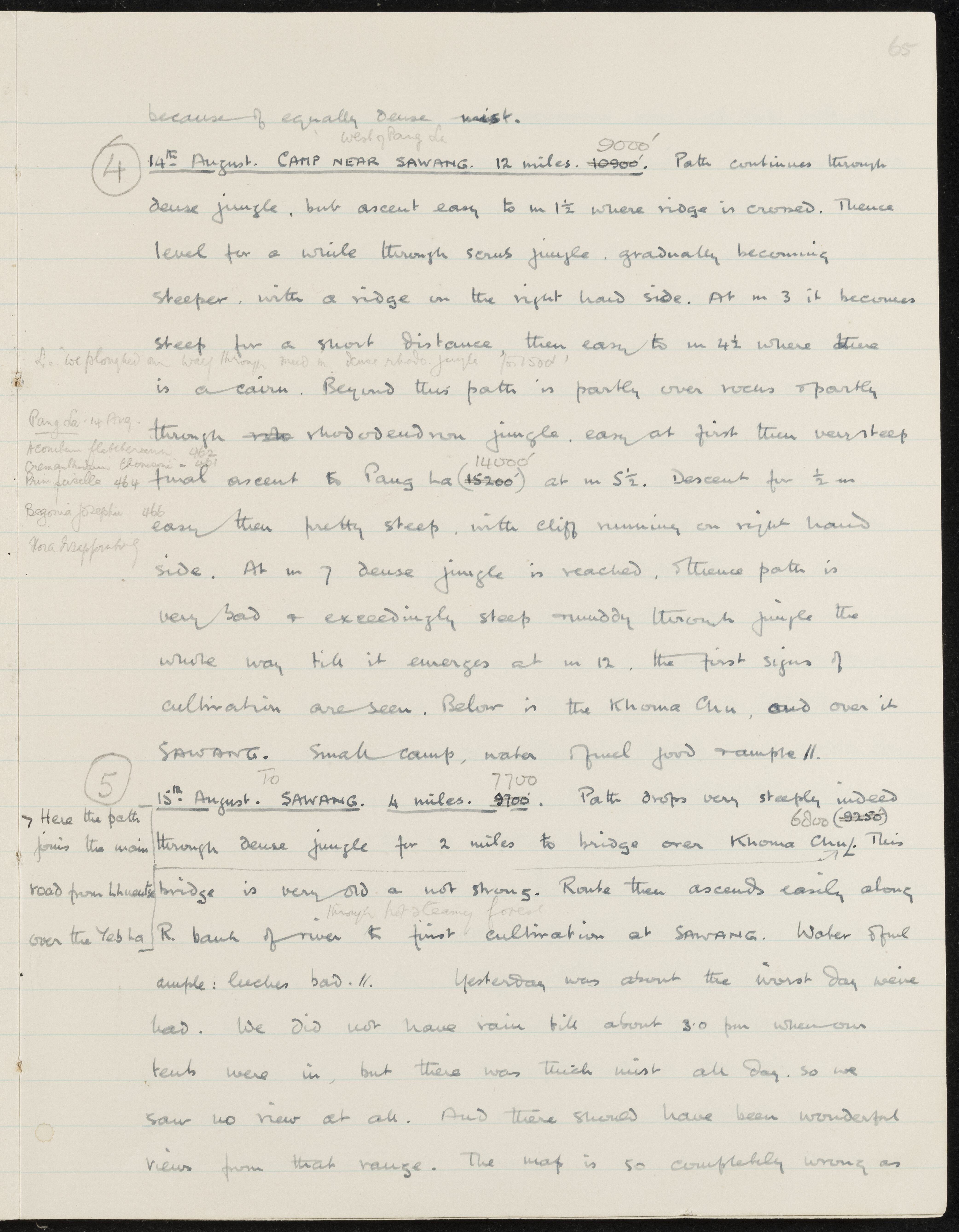
because of equally dense mist.
(4) 14th August. CAMP NEAR SAWANG. 12 miles. West of Pang La 9000'. Path continues through dense jungle, but ascent easy to m 1 1/2 where ridge is crossed. Thence level for a while through scrub jungle, gradually becoming steeper, with a ridge on the right hand side. At m 3 it becomes steep for a short distance, then easy to m 4 1/2 where there is a cairn. We ploughed our way through mud in dense rhodo jungle for 1500'. Beyond this path is partly over rocks & partly through rhododendron jungle, easy at first then very steep final ascent to Pang La (14000') at m 5 1/2. Descent for 1/2 m easy then pretty steep, with cliff running on right hand side. At m 7 dense jungle is reached, & thence path is very bad & exceedingly steep & muddy through jungle the whole way till it emerges at m 12, the first signs of cultivation are seen. Below is the Khoma Chu, and over it SAWANG. Small camp, water & fuel good & ample. //
Pang La. 14 Aug.
Aconitum fletcherianum 462
Cremanthodium thomsonii - 461
Primula 464
Begonia josephii 466
Flora disappointing
(5) 15th August. TO SAWANG. 4 miles. 7700'. Path drops very steeply indeed through dense jungle for 2 miles to bridge over Khoma Chu (6800'). Here the path joins the main road from Lhuentse over the Yeb La. This bridge is very old & not strong. Route then ascends easily along through hot steamy forest R. bank of river to first cultivation at SAWANG. Water & fuel ample: leeches bad. //
Yesterday was about the worst day we've had. We did not have rain till about 3.0 pm when our tents were in, but there was thick mist all day, so we saw no view at all. And there should have been wonderful views from that range. The map is so completely wrong as
Évaluation, élimination et calendrier de conservation
Accroissements
Mode de classement
Zone des conditions d'accès et d'utilisation
Conditions d'accès
Conditions de reproduction
Langue des documents
Écriture des documents
Notes de langue et graphie
Caractéristiques matérielle et contraintes techniques
Instruments de recherche
Zone des sources complémentaires
Existence et lieu de conservation des originaux
Existence et lieu de conservation des copies
Unités de description associées
Zone des notes
Identifiant(s) alternatif(s)
Mots-clés
Mots-clés - Sujets
Mots-clés - Lieux
Mots-clés - Noms
- Aconitum fletcherianum (Sujet)
- Begonia josephii (Sujet)
- Cremanthodium thomsonii (Sujet)
- Primula (Sujet)