Zona de identificação
Código de referência
Título
Data(s)
- 1933-08-12 - 1933-08-13 (Produção)
Nível de descrição
Dimensão e suporte
1 page
Zona do contexto
Nome do produtor
Entidade detentora
História do arquivo
Fonte imediata de aquisição ou transferência
Zona do conteúdo e estrutura
Âmbito e conteúdo
SUMMARY:
Diary describes a fine-weather traverse from below Karpo over Sokpo Pass with steep shale and scree, turning near Chioling and reaching a yak encampment at the foot of Mihrang La; the route recalls Tulung La. Botanical notes include several gentians and Swertia; one young Cremophilum was shot and bharal were seen, with identifications discussed with Sherriff. The following day begins with a steep ascent to Mihrang La from camp between Cha La and Chorten Namo.
CONTENT:
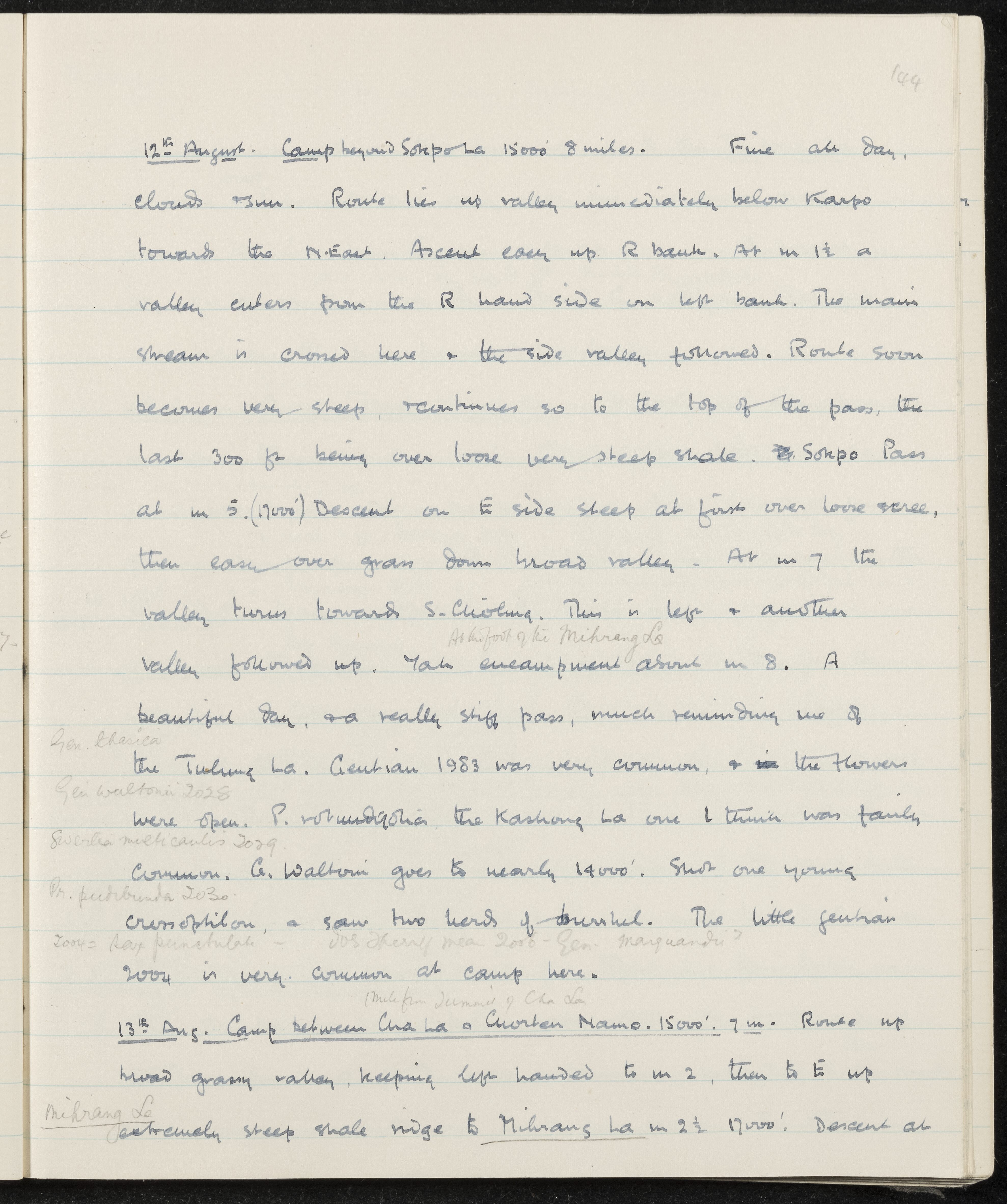
12th August. Camp beyond Sokpo La, 15,000 feet, 8 miles. Fine all day,
clouds and sun. Route lies up the valley immediately below Karpo
towards the North East. Ascent easy up the right bank. At mile 1 1/2, a
valley enters from the right-hand side on the left bank. The main
stream is crossed here and the side valley followed. The route soon
becomes very steep and continues so to the top of the pass, the
last 300 feet being over loose, very steep shale. Sokpo Pass
at mile 5 (17,000 feet). Descent on the east side is steep at first over loose scree,
then easy over grass down a broad valley. At mile 7, the
valley turns towards S. Chioling. This is left and another
valley followed up. At the foot of the Mihrang La, a yak encampment at about mile 8. A
beautiful day and a really stiff pass, much reminding me of
the Tulung La (Gen. kherica). Gentian 1983 was very common and the flowers
were open (Gen. waltonii 2028). P. rotundifolia, the Kashong La one I think, was fairly
common (Swertia multicaulis 2029). G. waltonii goes to nearly 14,000 feet. Shot one young
Cremophilum (Ph. pectinibunda 2030) and saw two herds of bharal. The little gentian
2034 (Gent. punctulata - Sherriff says 2035 = Gen. marquandii?) is very common at camp here.
(Mile from summit of Cha La)
13th August. Camp between Cha La and Chorten Namo, 15,000 feet, 7 miles. Route up
a broad grassy valley, keeping left-handed to mile 2, then to the east up
an extremely steep shale ridge to Mihrang La at mile 2 1/2 (17,000 feet). Descent at...
Avaliação, seleção e eliminação
Incorporações
Sistema de arranjo
Zona de condições de acesso e utilização
Condições de acesso
Condiçoes de reprodução
Idioma do material
Sistema de escrita do material
Notas ao idioma e script
Características físicas e requisitos técnicos
Instrumentos de descrição
Zona de documentação associada
Existência e localização de originais
Existência e localização de cópias
Unidades de descrição relacionadas
Zona das notas
Identificador(es) alternativo(s)
Pontos de acesso
Pontos de acesso - Assuntos
Pontos de acesso - Locais
Pontos de acesso - Nomes
- Sherriff (Assunto)
- Gen. kherica (Assunto)
- Gen. marquandii (Assunto)
- Gen. waltonii (Assunto)
- Gent. punctulata (Assunto)
- P. rotundifolia (Assunto)
- Ph. pectinibunda (Assunto)
- Swertia multicaulis (Assunto)