Área de identidad
Código de referencia
Título
Fecha(s)
- 1933-07-04 (Criação)
Nivel de descripción
Volumen y soporte
1 page
Área de contexto
Nombre del productor
Institución archivística
Historia archivística
Origen del ingreso o transferencia
Área de contenido y estructura
Alcance y contenido
SUMMARY:
In heavy rain, the party ascends from Omta Tso past Thita Tso to Thampe La (~16,000 ft) and descends to Thampe beside Thampe Tso, noting bearings and that Thampe Tso drains east to the Mangde Chu. Primula 3383 occurs near the pass, with masses of P. pusilla and common P. hopeana. The following day is a rainy halt with sleet, and a short valley exploration reveals another lake.
CONTENT:
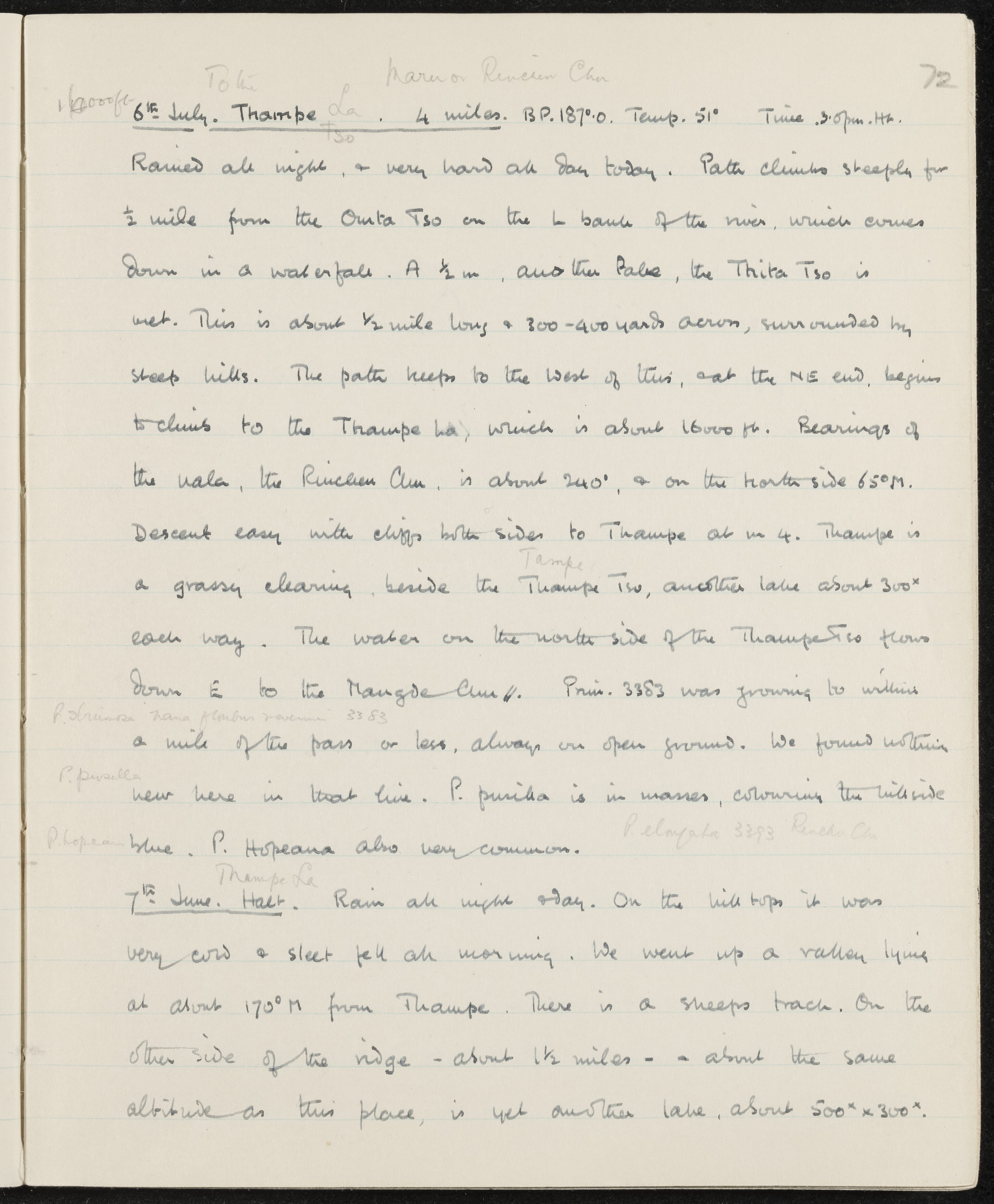
Toke Maru or Rinchen Chu
6th July. Thampe La. 4 miles. B.P. 187.0°. Temp. 51°. Time 3:00 p.m.
Rained all night, and very hard all day today. Path climbs steeply for ½ mile from the Omta Tso on the left bank of the river, which comes down in a waterfall. At ½ mile, another lake, the Thita Tso, is met. This is about ½ mile long and 300–400 yards across, surrounded by steep hills. The path keeps to the west of this, and at the NE end, begins to climb to the Thampe La, which is about 16,000 ft. Bearings of the nala, the Rinchen Chu, are about 240°, and on the north side 65°M. Descent easy with cliffs on both sides to Thampe at mile 4. Thampe is a grassy clearing beside the Thampe Tso, another lake about 300 yards each way. The water on the north side of the Thampe Tso flows down east to the Mangde Chu. Primula 3383 was growing to within a mile of the pass or less, always on open ground. We found nothing new here in that line. P. pusilla is in masses, coloring the hillside blue. P. hopeana also very common.
7th July. Halt. Rain all night and day. On the hilltops it was very cold and sleet fell all morning. We went up a valley lying at about 170°M from Thampe. There is a sheep's track. On the other side of the ridge—about 1½ miles—at about the same altitude as this place, is yet another lake, about 500 x 300 yards.
Valorización, destrucción y programación
Acumulaciones
Sistema de arreglo
Área de condiciones de acceso y uso
Condiciones de acceso
Condiciones
Idioma del material
Escritura del material
Notas sobre las lenguas y escrituras
Características físicas y requisitos técnicos
Instrumentos de descripción
Área de materiales relacionados
Existencia y localización de originales
Existencia y localización de copias
Unidades de descripción relacionadas
Área de notas
Identificador/es alternativo(os)
Puntos de acceso
Puntos de acceso por materia
Puntos de acceso por lugar
Puntos de acceso por autoridad
- P. Hopeana (Materia)
- P. pusilla (Materia)
- Primula (Materia)