Zone d'identification
Cote
Titre
Date(s)
- 1937-06-07 (Production)
Niveau de description
Étendue matérielle et support
1 page
Zone du contexte
Nom du producteur
Histoire archivistique
Source immédiate d'acquisition ou de transfert
Zone du contenu et de la structure
Portée et contenu
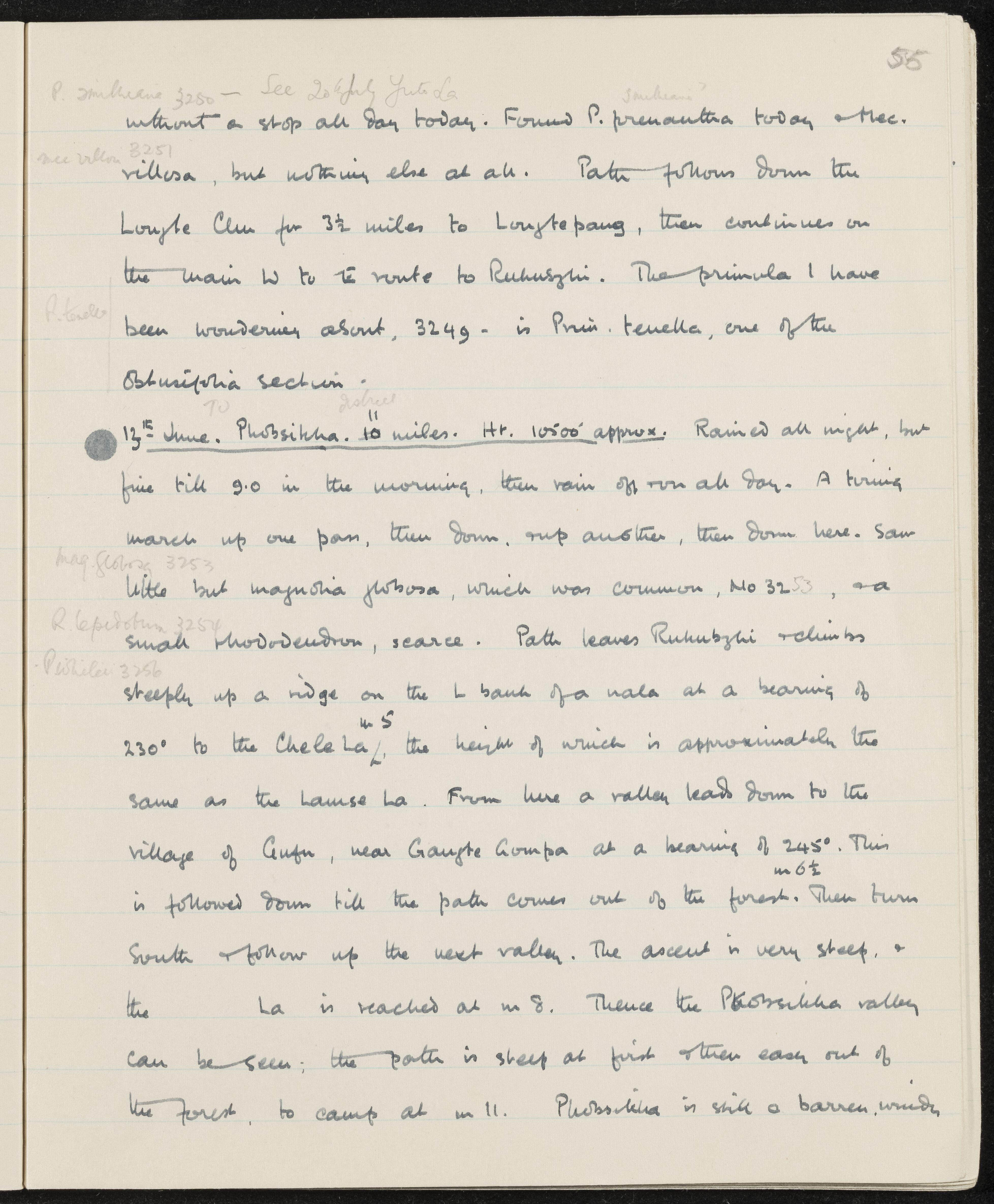
SUMMARY:
Notes describe following the Longte Chu to Longtepang and continuing toward Rukubzhi, with plant finds including Primula prenantha, Meconopsis villosa, and identification of Primula tenella. On 13th June, a 10-mile march to Phobsikha via Chele La is recorded, with rain, steep ascents and descents, and observations of Magnolia globosa and a small rhododendron.
CONTENT:
P. smithiana 3250 — See 20th July Yuto La.
...without a stop all day today. Found Primula prenantha today and Meconopsis villosa, but nothing else at all. Path follows down the Longte Chu for 3 1/2 miles to Longtepang, then continues on the main West to East route to Rukubzhi. The primula I have been wondering about, 3249 — is Primula tenella, one of the Obtusifolia section.
13th June. Phobsikha. 10 miles. Height 10,500' approx. Rained all night, but fine till 9:00 in the morning, then rain off and on all day. A tiring march up one pass, then down, and up another, then down here. Saw little but Magnolia globosa, which was common, No. 3253, and a small rhododendron, scarce. Path leaves Rukubzhi and climbs steeply up a ridge on the left bank of a nala at a bearing of 230° to the Chele La, the height of which is approximately the same as the Lausa La. From here a valley leads down to the village of Gufu, near Gangte Gompa at a bearing of 245°. This is followed down till the path comes out of the forest. Then turn South and follow up the next valley. The ascent is very steep, and the La is reached at mile 8. Thence the Phobsikha valley can be seen; the path is steep at first and then eases out of the forest, to camp at mile 11. Phobsikha is still a barren, windy...
Évaluation, élimination et calendrier de conservation
Accroissements
Mode de classement
Zone des conditions d'accès et d'utilisation
Conditions d'accès
Conditions de reproduction
Langue des documents
Écriture des documents
Notes de langue et graphie
Caractéristiques matérielle et contraintes techniques
Instruments de recherche
Zone des sources complémentaires
Existence et lieu de conservation des originaux
Existence et lieu de conservation des copies
Unités de description associées
Zone des notes
Identifiant(s) alternatif(s)
Mots-clés
Mots-clés - Sujets
Mots-clés - Lieux
Mots-clés - Noms
- Magnolia globosa (Sujet)
- Meconopsis villosa (Sujet)
- P. smithiana (Sujet)
- Primula prenantha (Sujet)
- Primula tenella (Sujet)