Área de identidad
Código de referencia
Título
Fecha(s)
- 1938-06-22 (Criação)
Nivel de descripción
Volumen y soporte
1 page
Área de contexto
Nombre del productor
Institución archivística
Historia archivística
Origen del ingreso o transferencia
Área de contenido y estructura
Alcance y contenido
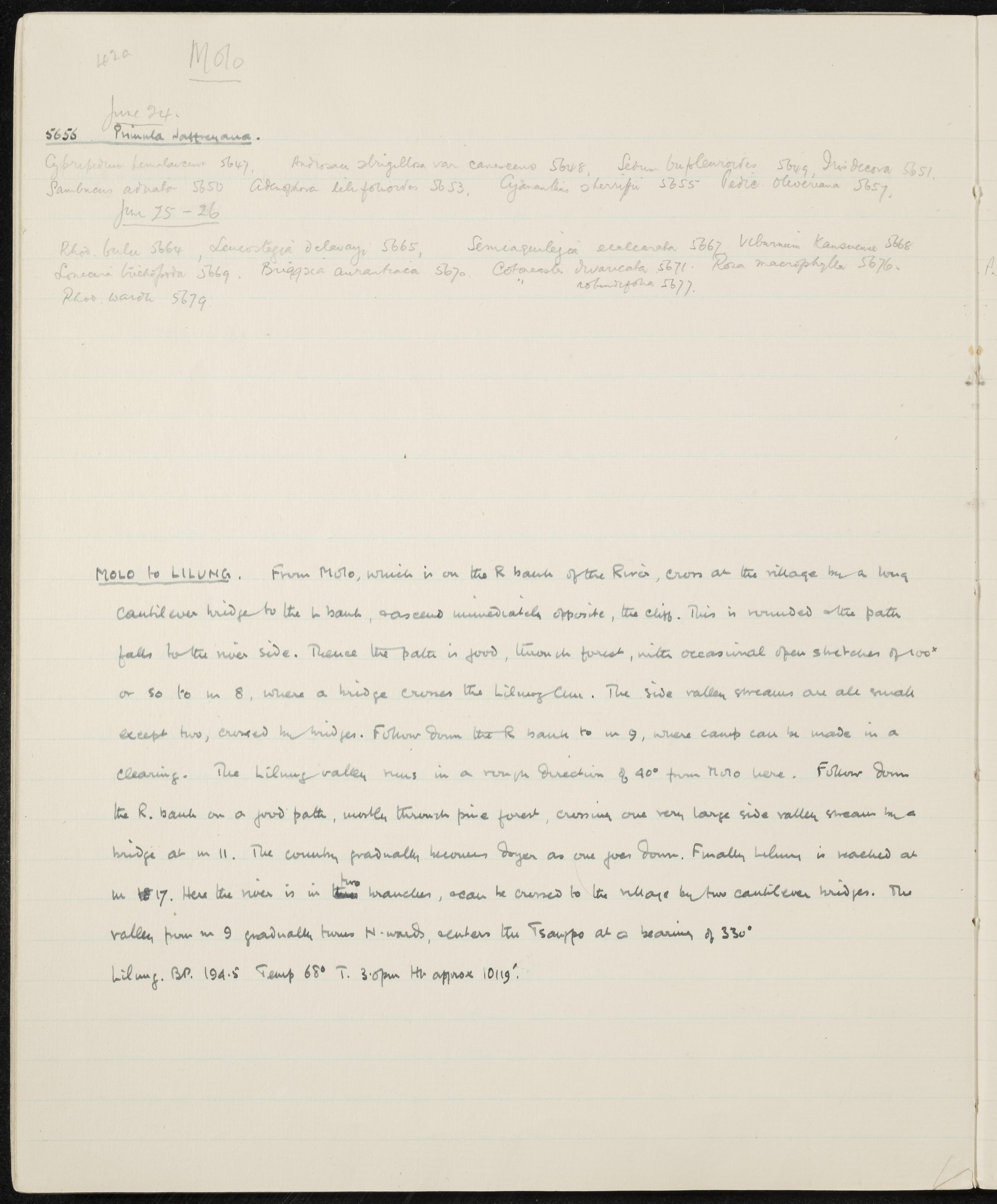
SUMMARY:
The page lists plant specimens collected on June 24 and 25–26, with specimen numbers in the 5647–5679 range. It provides detailed route directions from Molo to Lilung along river banks and bridges through forest and pine, with distances and bearings. At Lilung, observations include temperature 68° at 3:00 pm and an approximate elevation of 10,119 feet.
CONTENT:
42a Molo
June 24.
5656 Primula jaffreyana.
Cypripedium himalaicum 5647, Androsace strigillosa var. canescens 5648, Sedum bupleuroides 5649, Iris decora 5651.
Sambucus adnata 5650 Adenophora liliifolia 5653, Cyananthus sherriffii 5655 Pedicularis oliveriana 5657.
June 25-26
Rhod. bulu 5664, Leucostegia delavayi 5665, Semiaquilegia ecalcarata 5667 Viburnum kansuense 5668
Lonicera trichopoda 5669. Briggsia aurantiaca 5670. Cotoneaster divaricata 5671. Rosa macrophylla 5676.
Rhod. wardii 5679 " rotundifolia 5677.
MOLO to LILUNG. From Molo, which is on the R bank of the River, cross at the village by a long cantilever bridge to the L bank, and ascend immediately opposite, the cliff. This is rounded and the path falls to the river side. Thence the path is good, through forest, with occasional open stretches of 100 yards or so to m 8, where a bridge crosses the Lilung Chu. The side valley streams are all small except two, crossed by bridges. Follow down the R bank to m 9, where camp can be made in a clearing. The Lilung valley runs in a rough direction of 40° from Molo here. Follow down the R. bank on a good path, mostly through pine forest, crossing one very large side valley stream by a bridge at m 11. The country gradually becomes dryer as one goes down. Finally Lilung is reached at m 17. Here the river is in two branches, and can be crossed to the village by two cantilever bridges. The valley from m 9 gradually turns N-wards, and enters the Tsangpo at a bearing of 330°.
Lilung. BP. 19.4.5 Temp 68° T. 3.0pm Ht approx 10119'.
Valorización, destrucción y programación
Acumulaciones
Sistema de arreglo
Área de condiciones de acceso y uso
Condiciones de acceso
Condiciones
Idioma del material
Escritura del material
Notas sobre las lenguas y escrituras
Características físicas y requisitos técnicos
Instrumentos de descripción
Área de materiales relacionados
Existencia y localización de originales
Existencia y localización de copias
Unidades de descripción relacionadas
Área de notas
Identificador/es alternativo(os)
Puntos de acceso
Puntos de acceso por materia
Puntos de acceso por lugar
Puntos de acceso por autoridad
- Adenophora liliifolia (Materia)
- Androsace strigillosa var. canescens (Materia)
- Briggsia aurantiaca (Materia)
- Cotoneaster divaricata (Materia)
- Cyananthus sherriffii (Materia)
- Cypripedium himalaicum (Materia)
- Iris decora (Materia)
- Leucostegia delavayi (Materia)
- Lonicera trichopoda (Materia)
- Pedicularis oliveriana (Materia)
- Primula jaffreyana (Materia)
- Rhod. bulu (Materia)
- Rhod. rotundifolia (Materia)
- Rhod. wardii (Materia)
- Rosa macrophylla (Materia)
- Sambucus adnata (Materia)
- Sedum bupleuroides (Materia)
- Semiaquilegia ecalcarata (Materia)
- Viburnum kansuense (Materia)