Identity area
Reference code
Title
Date(s)
- 1933-07-21 (Creation)
Level of description
Extent and medium
1 page
Context area
Name of creator
Repository
Archival history
Immediate source of acquisition or transfer
Content and structure area
Scope and content
SUMMARY:
Botanical notes along the Kulu Phu Chu include multiple Primula and Gentiana species with specimen numbers, with observations around 11,500'. Detailed route directions run from Kongshong to Kucha Leku and up to the Kucha La, noting valley bearings, river crossings, forest and swampy meadows (including Kulu hungma with yak herds), and a side path to Member Tso and the Tamnyen Chu; entries are dated 23 July and at Kucha La on July 24.
CONTENT:
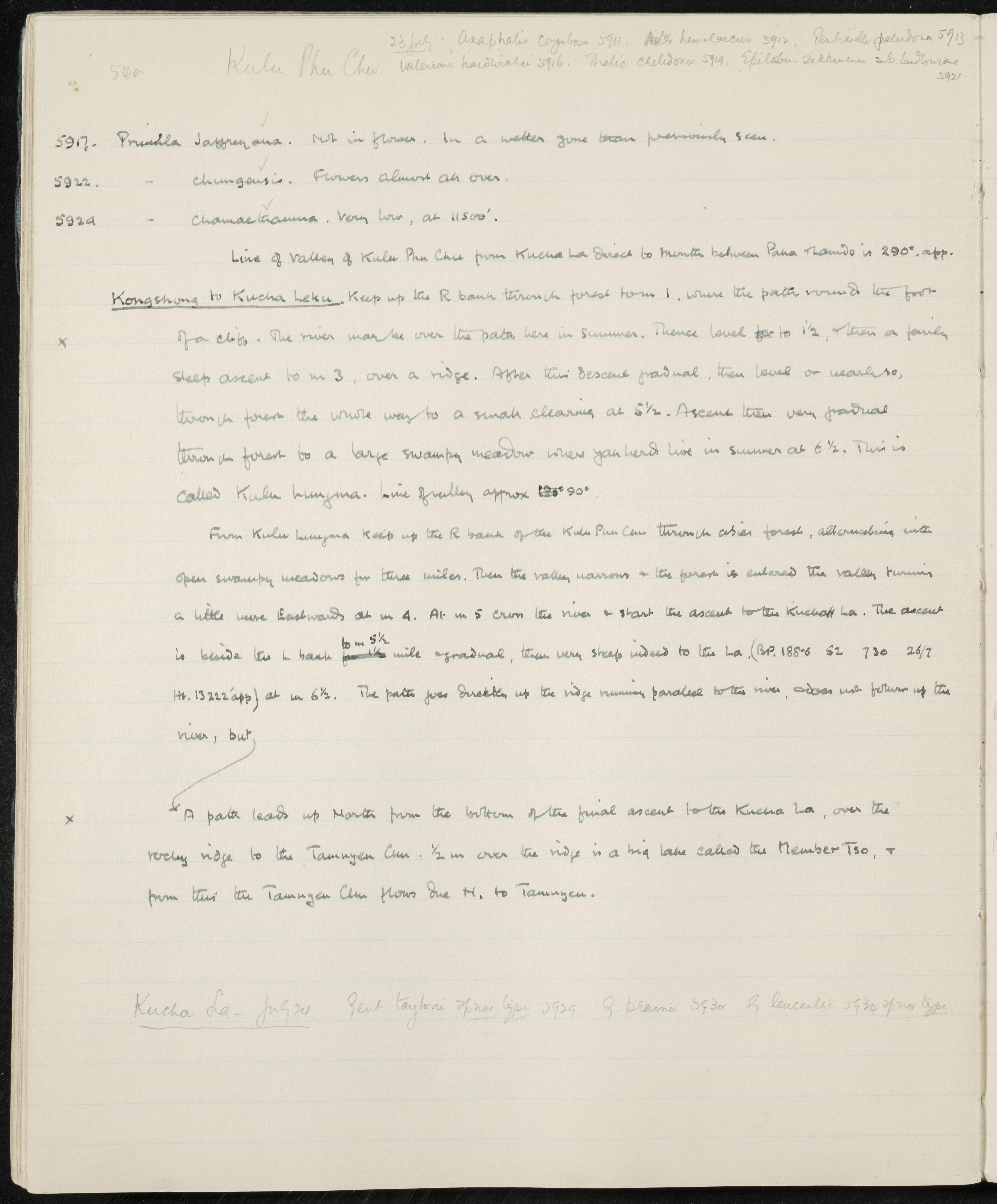
540 Kulu Phu Chu. 23 July. Anaphalis corymbosa 5911. Aster himalaicus 5912. Pedicularis paludosa 5913. Valeriana hardwickii 5916. Thalictrum chelidonii 5919. Epilobium sikkimense sub. ludlowianum 5921.
- Primula jaffreyana. Not in flower. In a wetter zone than previously seen.
- Primula chungensis. Flowers almost all over.
- Primula chamaethauma. Very low, at 11,500'.
Line of valley of Kulu Phu Chu from Kucha La direct to mouth between Pana Thamdo is 290° approx.
Kongshong to Kucha Leku. Keep up the Right bank through forest from mile 1, where the path rounds the foot of a cliff. The river may be over the path here in summer. Thence level to 1 1/2, then a fairly steep ascent to mile 3, over a ridge. After this descent gradual, then level or nearly so, through forest the whole way to a small clearing at 5 1/2. Ascent then very gradual through forest to a large swampy meadow where yak herds live in summer at 6 1/2. This is called Kulu hungma. Line of valley approx 90°.
From Kulu hungma keep up the Right bank of the Kulu Phu Chu through Abies forest, alternating with open swampy meadows for three miles. Then the valley narrows and the forest is entered, the valley turning a little more Eastwards at mile 4. At mile 5 cross the river and start the ascent to the Kucha La. The ascent is beside the Left bank to mile 5 1/2, gradual, then very steep indeed to the La (BP. 188.6 52 730 26/7 Ht. 13,222' approx) at mile 6 1/2. The path goes directly up the ridge running parallel to the river, does not follow up the river, but,
A path leads up North from the bottom of the final ascent to the Kucha La, over the rocky ridge to the Tamnyen Chu. 1/2 mile over the ridge is a big lake called the Member Tso, and from this the Tamnyen Chu flows due North to Tamnyen.
Kucha La - July 24. Gentiana taylorii sp. nov. type 5929. Gentiana praeclara 5930. Gentiana leucantha 5934 sp. nov. type.
Appraisal, destruction and scheduling
Accruals
System of arrangement
Conditions of access and use area
Conditions governing access
Conditions governing reproduction
Language of material
Script of material
Language and script notes
Physical characteristics and technical requirements
Finding aids
Allied materials area
Existence and location of originals
Existence and location of copies
Related units of description
Notes area
Alternative identifier(s)
Access points
Subject access points
Place access points
Name access points
- Anaphalis corymbosa (Subject)
- Aster himalaicus (Subject)
- Epilobium sikkimense sub. ludlowianum (Subject)
- Gentiana leucantha (Subject)
- Gentiana praeclara (Subject)
- Gentiana taylorii (Subject)
- Pedicularis paludosa (Subject)
- Primula chamaethauma (Subject)
- Primula chungensis (Subject)
- Primula jaffreyana (Subject)
- Thalictrum chelidonii (Subject)
- Valeriana hardwickii (Subject)