Área de identidad
Código de referencia
Título
Fecha(s)
- 1933-07-19 (Criação)
Nivel de descripción
Volumen y soporte
1 page
Área de contexto
Nombre del productor
Institución archivística
Historia archivística
Origen del ingreso o transferencia
Área de contenido y estructura
Alcance y contenido
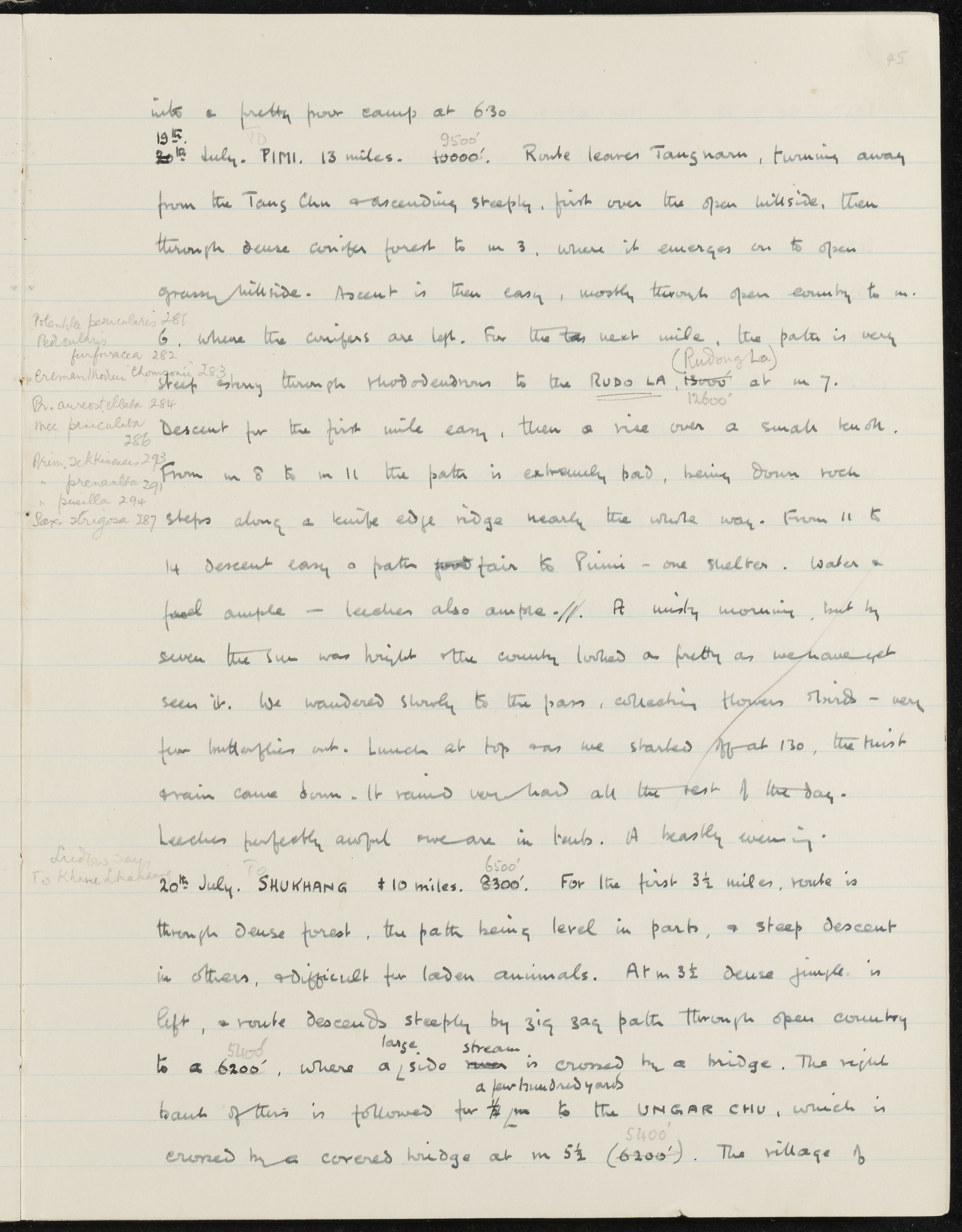
SUMMARY:
Route descriptions for 20th July describe a steep ascent from Tangnam away from the Tang Chu through conifer forest to the Rudo La (Rudong La) pass, then a difficult knife-edge descent to Pimi, followed by a stage toward Shukhang with bridges over side streams and the Ungar Chu. Notes mention collecting flowers and birds, mist turning to heavy rain, severe leeches, and camping in tents.
CONTENT:
into a pretty poor camp at 6.30
20th July. PIMI. 13 miles. 9500'. Route leaves Tangnam, turning away from the Tang Chu and ascending steeply, first over the open hillside, then through dense conifer forest to m 3, where it emerges on to open grassy hillside. Ascent is then easy, mostly through open country to m 6, where the conifers are left. For the next mile, the path is very steep and stony through rhododendrons to the RUDO LA (Rudong La), 12600' at m 7.
Descent for the first mile easy, then a rise over a small knob. From m 8 to m 11 the path is extremely bad, being down rock steps along a knife edge ridge nearly the whole way. From 11 to 14 descent easy and path fair to Pimi - one shelter. Water and fuel ample - leeches also ample. A misty morning, but by seven the sun was bright and the country looked as pretty as we have yet seen it. We wandered slowly to the pass, collecting flowers and birds - very few butterflies out. Lunch at top and we started off at 1.30, the mist again came down. It rained very hard all the rest of the day. Leeches perfectly awful and we are in tents. A beastly evening.
20th July. SHUKHANG 10 miles. 6500'. For the first 3 1/2 miles, route is through dense forest, the path being level in parts, and steep descent in others, and difficult for laden animals. At m 3 1/2 dense jungle is left, and route descends steeply by zigzag path through open country to a 5400', where a large side stream is crossed by a bridge. The right bank of this is followed for a few hundred yards to the UNGAR CHU, which is crossed by a covered bridge at m 5 1/2 (5400'). The village of