
GB 235 RBG/1/JHB/1/1/J/J4
·
Item
·
1853
Part of Royal Botanic Garden Edinburgh Institutional Archives
2091 results with digital objects
Show results with digital objects
GB 235 CAV/2/2/2
·
Item
·
1903
Part of George H. Cave Collection
LSH/1/1/10/1/32
·
Part
·
1933-10-10
Part of The Ludlow & Sherriff Collection
SUMMARY:
Cora writes to Mrs. Parks apologizing for a delayed reply, sharing that she has been busy, and expressing hope she is well. She praises Mrs. Parks' courageous act, offers help, and asks for a reply.
CONTENT:
I have received your letter and was glad to hear from you. I am sorry I have not written sooner but I have been very busy. I hope you are well and that everything is going okay with you. I am still working at the same place and things are going okay. I have been very busy lately with work and other things. I hope to see you soon. Please write back when you have a chance. I would love to hear from you.
Dear Mrs. Parks,
I have been thinking of you so much since I read about your brave act. I wanted to write and tell you how much I admire your courage. It was a wonderful thing you did and I hope it will lead to better things for all of us. I am praying for you and I hope you are well. Please let me know if there is anything I can do to help.
Sincerely,
Cora
GB 235 GBY/7/4/1/1
·
Item
·
11 May 1995
Part of Professor Mary Gibby Collection
1 page letter written reply by Ms. Dorothee Ammann, T. Reichstein's secretary, to Prof. C-J Widen.
Ms. Ammann mentions providing Prof. Widen with a copy of Reichstein's CV as she believed he might be interested in knowing more about his life.
Ammann, Frau Dorothee
GB 235 GBY/5/2/1/6
·
Item
Part of Professor Mary Gibby Collection
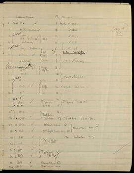
LSH/1/1/2/1/345
·
Part
·
1934-10-24 - 1934-09-07
Part of The Ludlow & Sherriff Collection
SUMMARY:
Checklist of letters sent and received with dates and postage notes (air/ordinary), referencing locations such as Marsha, Pimbong, Sahdan, Mago, T'gong, Dib La, and T'yangzi. Entries include dates 24/10/1934 and 07/09/1934.
CONTENT:
Letters Home From Home
(200.6 / 75.0)
- Sent 13.6. ✓ 1. 30/5. ✓ 10.6.
- 22.6. Marsha ✓ 2. ✓ 23.6.
- x 25.9 ✓ air 3. ✓ 18.7.
- 28.6 Pimbong 28.6 ordinary 4. ✓ 17.8
- x 25.9 ✓ air Sahdan 5. ✓ 17.8
- ordinary ✓ 10.7. Sahdan 5+6. 24.10.34. ✓
- ordinary 18/7 ✓ 7.
- Received 18/7 ✓ Mago 25/7 8. ✓ 5.9. T'gong.
- ord. 9.
- x 25.9 ✓ A.M. He 25/8 10.
- Ord. ✓ 11. 12.9. ✓ Dib La.
- ord La 12. ✓ 27.9. Dib La.
- x 25.9 ✓ A.M. ✓ T'yangzi 7.9.34 13.
- x 2
GB 235 RBG/1/JHB/1/1/A
·
Subseries
·
1830 - 1884
Part of Royal Botanic Garden Edinburgh Institutional Archives
GB 235 RBG/1/JHB/1/1/B
·
Subseries
·
1829 - 1884
Part of Royal Botanic Garden Edinburgh Institutional Archives
GB 235 RBG/1/JHB/1/1/C
·
Subseries
·
1826 - 1884
Part of Royal Botanic Garden Edinburgh Institutional Archives
GB 235 RBG/1/JHB/1/1/D
·
Subseries
·
1829 - 1884
Part of Royal Botanic Garden Edinburgh Institutional Archives