Showing 6828 results

Archival description
2091 results with digital objects Show results with digital objects
LSH/1/1/2/1/128 · Part · 1933-07-18
Part of The Ludlow & Sherriff Collection

SUMMARY:
The page records altitude calculations for Cha La and Camp Rong, and notes on Tsuk village on the left bank of the Tsuk Chu. It mentions ascending the Cha La pass, passing the Chöde, and descending to Chukar, with a reference to a story of Guru Rinpoche.

CONTENT:
18

Dunkar - 58

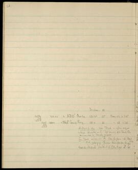
14584 729.20 = 15313' Chala 185.20 55° Mean of 2 1.05
729
15313
12998 650.90 = 13648' Camp Rong. 188.0 55 " = 56 = 1.05
650
13648

Ludlow p. 94 na Tsuk - a fair sized
village situated on the left bank of the Tsuk Chu
surrounded by barley fields.
From Tsuk ascended the Cha La pass - the highest pass.
N.B. story of Guru Rinpoche p. 95.
Past the Chöde descent to Chukar. L. 96.
LSH/1/1/3/3/184 · Part · 1983-05-05
Part of The Ludlow & Sherriff Collection

SUMMARY:
Route directions describe a descent from a second pass to Tahtsang RH, then a steep climb to the Sha ngu La with an alternate road to Chienchao, followed by a descent to a bridge leading to Somtsang. Additional notes cover Yüto to Chakta Trang and on to the Kankyu La, with details on forested sections, stream crossings, and rough road conditions.

CONTENT:
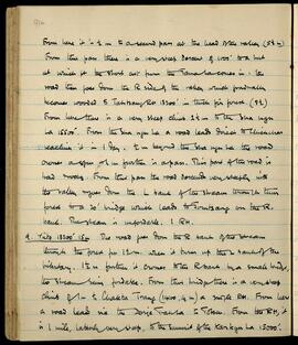
From here it is 1/2 m to a second pass at the head of the valley (5 1/2 m). From this pass there is a very steep descent of 1000' to a link at which pt the short cut from the Tama La comes in. The road then goes down the R side of the valley which gradually becomes wooded to Tahtsang RH 13200' in thick fir forest. (9 1/2)

From here there is a very steep climb 2 1/2 m to the Sha ngu La 15500'. From the Sha ngu La a road leads direct to Chienchao reaching it in 1 day. 1/2 m beyond the Sha ngu La the road crosses a spur & 1 m further is a pass. This part of the road is bad & rocky. From this pass the road descends very steeply into the valley & goes down the L bank of the stream through thin forest to a 20' bridge which leads to Somtsang on the R. bank. The stream is unfordable. 1 RH.

  1. Yüto 13200' 15m The road goes down the R bank of the stream through the forest for 1 1/2 m. when it turns up the L bank of the tributary. 1 1/2 m further it crosses to the R bank by a small bridge, the stream being fordable. From this bridge there is a very steep climb of 1 m to Chakta Trang (14100, 4 m) a single RH. From here a road leads via the Dorje Trahsa to Totsen. From the RH, it is 1 mile, latterly very steep, to the summit of the Kankyu La 15000'.
LSH/1/1/3/3/186 · Part · 1983-05-05
Part of The Ludlow & Sherriff Collection

SUMMARY:
The page details a steep descent from a pass to Simoneri RH, then down to Yümo and up the valley past a bridge to Gompo Rong RH and Yüto, noting fuel availability, lack of crops, and a road via the Pip La to Chiksam. A separate stage describes a very stony road to the Takar La, a steep descent to the junction with the Char La road, and onward to Sangachöling, with distances and elevations.

CONTENT:
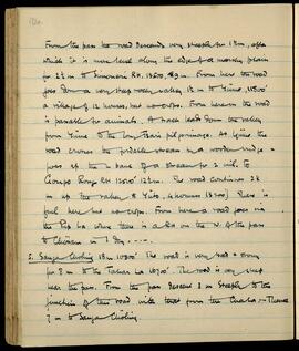
From the pass the road descends very steeply for 1 1/2 m, after which it is more level along the edge of a marshy plain for 2 1/2 m to Simoneri RH. 13500, 29 m. From here the road goes down a very steep rocky valley 1 1/2 m to Yümo, 11800' a village of 12 houses, but no crops. From here on the road is passable for animals. A track leads down the valley from Yümo to the Tsari pilgrimage. At Yümo the road crosses the fordable stream by a wooden bridge, goes up the L bank of a stream for 2 mil. to Gompo Rong RH 12500' 12 1/2 m. The road continues 2 1/2 m up the valley to Yüto, (4 houses 13200') There is fuel here but no crops. From here a road goes via the Pip La where there is a RH on the N. of the pass to Chiksam in 1 day. ---

  1. Sangachöling 18 m 10900' The road is very bad & stony for 8 m to the Takar La 16700'. The road is very steep near the pass. From the pass descend 3 m steeply to the junction of this road with that from the Char La. --- Thence 7 m to Sangachöling.
LSH/1/1/2/1/147 · Part · 1933-07-18
Part of The Ludlow & Sherriff Collection

SUMMARY:
Route notes describe travel up the valley past summer yakherd huts and a side valley with the glacier called SESUM, crossing the main river and a steep ascent to the Me La (Ht. 14956) before descending through conifers to Shingbe. Mentions an old landslide with a boulder bearing two houses, possible fording difficulties, and bearings to the Yombu Chu–Mena Chu junction and continuation of Yombu Chu.

CONTENT:
72

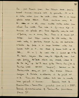
Chu, first through forest, then through scrub, passing several summer-occupied huts of yakherds. At m 2 a valley enters from the north, where there is a large glacier called SESUM. Route continues easy to SH, at m 5 1/2, where another valley enters from almost due north. This river is of some size in summer as glacier fed. Some difficulty may be had in fording on a sunny day. There is a small foot bridge. Just before meeting the side valley, the main valley is partially blocked by an old landslide, beside the path is a huge boulder with two houses built on it, a stair of stones built up to them. At m 7 the main river is forded to the R. bank, again there may be difficulty here. Just after fording the path climbs very steeply indeed to the Me La, up the R bank of the Yombu Chu. (Ht. of Me La 14956 BP. 185.8 Temp 64°). Descent on the Bhutan side easy at first, then steeper through conifers to Shingbe, a clearing in the jungle at m 12. There are three wooden huts here & usually some yakherds in summer. Bearing back to Yombu Chu - Mena Chu junction from m 7 = 288°. Bearing of continuation of Yombu Chu from same place 77°.

LSH/1/1/2/1/121 · Part · 1933-07-18
Part of The Ludlow & Sherriff Collection

SUMMARY:
The diary describes the path along the north side of the valley to the Sang La, then a steep descent to Dongkar and its Dzong on the right bank of the Nyamjang Chu, noting cultivation, trees, and camp conditions. Weather was perfect until crossing the pass, when mist caused the party to stray onto the wrong road, realizing at 5:00 pm they should have kept to the right bank to cross a shoulder pass.

CONTENT:
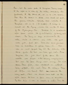
Chu, but the main path to Dongkar Dzong keeps to the right or N side of the valley, ascending thus gradually to the SANG LA, at m 14 (Ht. 17,125'). Over this the descent is steep, over shale at first, then grassy hillside, finally bare hillside to Dongkar, at m 17 (Ht 13,350'). A bridge is crossed at the Dzong, which lies on the R bank of the Nyamjang Chu. Dongkar is a considerably sized place with lots of cultivation of barley and wheat. The Dzong is large and commands the valley, which is narrow, very well. C.G. good, water good, fuel fair. There are some juniper trees, buckthorn, and poplar trees. This was a most perfect day till the evening, and the views quite the best we have yet had. From Dongkar till just short of the pass, the weather was perfect and the scenery magnificent. But over the pass things went wrong. The mist came down first, one wandered on without being stopped, till well down the valley. Then at 5:00 pm we heard that we were on the wrong road, and that we should have kept up the right bank to cross a pass over a shoulder. By this time I was a couple of miles from the

LSH/1/1/2/1/75 · Part · 1933-07-18
Part of The Ludlow & Sherriff Collection

SUMMARY:
Notes minor friction between the Kashmiris and Puitso, Kurbip, and Danung. Describes an 8-mile march over Tulung La to Longur with steep loose shale, reaching the Tulung (Goshu) Chu, and records camp conditions including fair grazing, ample fuel, clean water, and rain.

CONTENT:
36

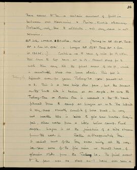
There seems to be a certain amount of friction between our Kashmiris & Puitso, Kurbip & Danung. Probably only due to altitude, in any case is not serious.

22nd July. LONGUR. 8 miles. 13635' (Tulung La B.P. 181.9°. Temp. 50° = Corr. ht. 17130' : Longur B.P. 187.8° Temp 50° = Corr. ht 13635'.) Continue up R bank of river for 1 1/2 miles, then cross to left bank at m 1 1/2. Ascent steep for 1/2 mile then easy till the final ascent of 150 ft, which is exceedingly steep over loose shale. This bit is difficult even for yaks. Tulung La 17430' passed at m 3. This is a bare knife edge pass, but the descent on the south side is taken at an angle. At m 4 the Tulung Chu or Goshu Chu is reached & the R. bank followed down to camp at Longur at m 8. The hillside is very steep & mostly consists of loose shale. In very wet weather this is liable to give some trouble. Grazing fair, clean water from a little below camp. Fuel ample. Longur is at the junction of a side stream from the west. // Rather a disappointing day. It rained most of the

LSH/1/1/9/1/45 · Part · 1933-05-07
Part of The Ludlow & Sherriff Collection

SUMMARY:
The diarist, ill with bronchitis, outlines a staged route through multiple settlements, then reaches Mashina and pushes the coolies on to Dunkhar, revising planned departure dates. Many people are sick, including a man of Wangmoo who was injured, and the writer discusses difficulties securing coolies due to local allegiances to H.H., Wangmoo, Ani Choden, and Pema Dechen, before deciding to move on.

CONTENT:
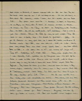
Bad night & Bronchitis. I cannot manage hills as they are here. They are too hard work now for me. I got no sleep at all. We are all having a late start this morning, which I hate, but the coolies are so damn tired. Our plans must now be: 11 Dunkhar, 12 Halt, 13 Shambling, 14 a camp on Kuru Chu R bank, 15 Lhumbe, 16 Halt, 17 Takila, 18 Ungar, 19 Pimi, 20 Tang, 21 Halt, 22 Shabjetang on the Bumthang Chu, 23 Halt, 24, 25, 26 northwards, 27th Waitsang. That is a lot of good time wasted, though the Rudu La may be good via Tang; the route is new & fairly high, so should be of interest.

Later. We got to Mashina in very good time, so I asked the coolies to go on to Dunkhar, which they did, but were all in, tired, at 3.0 p.m., having come very steeply down over 5000' & up nearly 2000'. We have altered dates a little, & will leave here on 12th, and Lhumbe 14th, Ungar 16th, Tang 18th, Shabjetang 20th & halt there. Many sick people here, as I was specially tired, including one of Wangmoo's men who fell off his horse & made a hole right through into his mouth with a stone.

In some ways, it may be well to leave this area. Coolies might have been difficult. They have to come from here, & would have to come 3 days' march before reaching me to move me 1 day's march. And then to Waitsang would have taken, I'm told, no less than 8 nights on the way, besides going into Tibet. All the men up the Kuru Chu valley are not available as coolies. Here, nearly all are H.H.'s subjects, personal servants: so they would come with me. At Shambling, all are Wangmoo's, Ani Choden & Pema Dechen's. At Tungyang they are Wangmoo's. These people do not do the ordinary coolie work, except for their owners. Anyway we are off now, for better or worse; it does not matter what happens here.

LSH/1/1/2/1/2 · Part
Part of The Ludlow & Sherriff Collection

SUMMARY:
Overview page listing the 1934 expedition route across Bhutan and Tibet. The itinerary runs from Menoka Tea Estate to Rangiya via numerous villages, rivers, passes, valleys, and dzongs.

CONTENT:
BHUTAN and TIBET.
1934

Route: Menoka Tea Estate - Diwangiri - Trashigong -
Gamri Chu - Sakden - Muktur - Tawang - Tsona - Tulung La -
Nyuri - Lap - Mago area (Luguthang & Chigapnaga) - Tulung
La - Tsona - Gonpo La - Dongkar Dzong - Cha La - Cho La -
Me La - Trashiyangsi valley - Chorten Korra - Dib La - Chorten
Korra - Sana - Trashiyangsi Dzong - Trashigong Dzong - Sakden -
Trashigong - Pintsogong - Chunkar - Diwangiri - Rangiya.

LSH/1/1/2/1/15 · Part · 1924-06-23
Part of The Ludlow & Sherriff Collection

SUMMARY:
The diary describes travel from camp over multiple ridges with several river crossings, including a bridge where the mules swam, reaching cultivation and houses around 3300' before continuing to camp. On 24th June at Chunkar (12 miles; 6,041'; 80°), the day was mostly fine with brief showers, the route mostly a steady rise, and big lilies noted on a cliff around mile 6; birds and butterflies were numerous but flowers scarce. Plant collections listed include species of Argostemma, Impatiens, Clerodendrum, Begonia, Selaginella, Dryopteris, Callicarpa, Clitoria, Torenia, and Polygala.

CONTENT:
6

Argostemma sarmentosa 538
Impatiens 539
Clerodendrum hastatum 540
Begonia aff megaphylla 544
Selaginella monospora 543
Dryopteris cylindrostachya 545
Callicarpa vestita 546

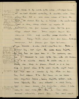
Left camp to the north of the ridge, dropped down all we had climbed yesterday, to another river. Then along this till a side river comes in from the East. We crossed this by a bridge - the mules swam - showed a very steep climb up again to cultivation and a few houses near the top of a ridge about 3300'. Down again beyond this, over a river and up another ridge shoulder to camp. Many birds about but few seen. Butterflies numerous, but flowers few and far between.

24th June. CHUNKAR. 12 miles. (200.6) = 6,041' Temp. 80°. Rather a pleasant day. Last night the moon shone brightly, the only time we have seen it. The morning was fine and remained so most of the day, with odd showers 15 or 20 minutes. Nearly the whole way is a steady rise, steep in places. About mile 6 a big cliff is passed close to the road on the right hand side, we saw a number of big lilies on this.

Clitoria acuminata 548
Torenia vagans 549
Polygala ar

LSH/1/1/4/1/89 · Part · 1933-08-15
Part of The Ludlow & Sherriff Collection

SUMMARY:
The writer describes a steep route over open hillsides to the Dza La, then a very steep descent toward the Tsokar, noting firs, a hut, and a glacier by the lakes. A small white Meconopsis was found; during a halt above the Nga La, additional Primula observations were made, and Ludlow brought in a specimen.

CONTENT:
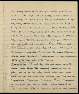
then a steep ascent again over open hillside to the Pangha at m 5 1/2. Here again there is a drop, this time steeply for about 300 ft, then ascent gradual through rhododendrons to open stony valley reached at m 6 1/2. Thence more or less E to the Dza La at m 8. The last mile is steep over stony hillside. Descent of E side very steep at first. The Tsokar consist of 2 small lakes about 2 1/2 m behind the Dza La and 2000 ft below. Beside the lakes are fir trees and a hut. A glacier falls very steeply into one lake. Found today a little white Meconopsis (Mec. argemonantha) 2531 which does not seem to answer to M. lyrata or primulina, though near the latter. Otherwise nothing much of interest. P. Valentiniana is very common on the right of the path going to the Dza La.

1st September. Halt. Camp above Nga La. A lovely day, with mist coming up in the evening and some thunder then. Afterward cleared up and was very pretty. Went up the steep valley directly behind camp, and came across one new, but uninteresting primula (P. hookeri) 2535. There were also P. Valentiniana, P. Jonardunii, P. nivalis sp., P. 1621 (Tsariensis), P. Cawdoriana, and a very small one, none in flower. Ludlow brought in one 2536 (Caveana) which seems to be an Obtusifolia primula, also no flowers.