Showing 6828 results

Archival description
2091 results with digital objects Show results with digital objects
LSH/1/1/9/1/43 · Part · 1933-05-07
Part of The Ludlow & Sherriff Collection

SUMMARY:
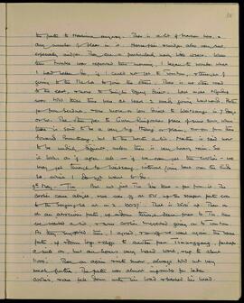
The writer considers westward routes toward Weitsang without recrossing the Rudu La, noting options from Serdua or via Guru Rinpoche's place toward Bumthang, while describing severe insect troubles. On 9th May they start early, climb to the Sergung La (10,027'), reach Tin, then push on toward Tomtom over the difficult Timunggang pass in snow, where a laden coolie falls and injures his head.

CONTENT:
the path to Tashina anyway. There is a lot of bracken here, and any number of fleas in it. Horseflies and midges also very bad, especially midges. They are a particularly nasty little insect. When this trouble was reported this morning, I began to wonder what I had better do, if I could not get to Tomtom, and thought of going to the Me La to join the others. There is no other road to the east, and none to Singhi Dzong direct. Last night Ngudup was told that there were at least 2 roads going westward. Both go from Serdua, one more or less direct to Weitsang in 7 days or so. The other goes to Guru Rinpoche's place of some sort, where there is said to be a very big 'thang' or plain, and so on from there towards Bumthang, but to the north a bit. Neither is said now to be unduly difficult, unless there is very heavy rain. So it looks as if after all — if we can get the coolies — we may get through to Weitsang, without going back over the Rudu La, which I do not want to do.

9th May. Tin. But not just Tin like that — far from it. The coolies came alright, and we were off at 5.15, up the steepest path ever to the Sergung La at 10,027'. That is 2500' up. Then on, on an atrocious path, up and down through dense forest to Tin. Here we waited a bit, and some coolies suggested going on to Tomtom. As they suggested this, I agreed, and so off we went again, the same path, up and down logs and cliffs to another pass Timunggang, perhaps a mile on, but an hour's very hard work, and up to about 11,000'. Then on again into snow, always cold but not very much further. The path was almost impossible for laden coolies, and one fell down with his load and bashed his head.
LSH/1/1/8/1/92 · Part · 1938-04-09
Part of The Ludlow & Sherriff Collection

SUMMARY:
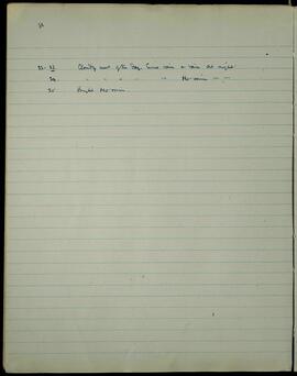
Cloudy conditions are noted on the 22nd–23rd with some rain, including at night. The 24th was cloudy without rain, and the 25th was bright with no rain.

CONTENT:
86

22-23. Cloudy most of the day. Some rain & rain at night.

  1. Cloudy most of the day. No rain.
  2. Bright. No rain.
LSH/1/1/8/1/20 · Part · 1946-12-02 - 1946-12-11
Part of The Ludlow & Sherriff Collection

SUMMARY:
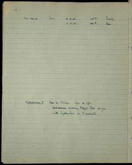
Records minimum temperatures at Shu on 2–3 December 1946. Notes Kodachrome roll 7 covering the journey from Shu to Miling from 4 to 11 December, including scenes crossing the Mayu Chu on 11 December with Gyala Peri in the background.

CONTENT:
17

Min temp. Shu. 2.12.46. 24° F. Cloudy.

    • 3.12.46. 23° F. Clear.

Kodachrome 7. Shu to Miling. 4/12 to 11/12
last scenes crossing Mayu Chu on 11/12
with Gyala Peri in background.

LSH/1/1/8/1/72 · Part · 1947-02-20
Part of The Ludlow & Sherriff Collection

SUMMARY:
Daily weather notes from 26 February to 6 March are recorded, followed by a note on the impassable road to Gompo Ne and the limited supplies available in villages. The writer lists staple foods and remarks on numerous large and small landslides in the lower Po Tsangpo valley.

CONTENT:
66.

26-27th Feb: Cleared at night. 27th sparklingly bright.
27-28th Feb: Rain at night. 28th cloudy with sunny patches.
28-1st March: Little rain at night. 1st a clear bright day.
1-2nd March: - - - 2nd mostly clear sky.
2-3rd March: Min 41°. Lightly clouded night. Sun clouded day. Hot. Max about 78°.
3-4th March: Min 46°. Some rain at night. Cloudy day.
4-5th March: Min 46°. Rain all night, rained hard all day 5th.
5-6th March: ? Rain all night + rain all 6th.

Note about road to Gompo Ne ship line.
Road is impassable everywhere for ponies. Supplies in very limited quantities are available at nearly every village, and consist of barley, wheat, maize, millet, fowls, barking deer + takin meat, milk. In summer to these could be added eggs. Some turnips + radishes, probably dried, are also available. The road is not easy: 1st + 2nd days could be made into one march perhaps, but the others are long in time + effort. A most noticeable thing about the lower Po Tsangpo valley is the number of very large landslides + small ones too, on both sides. Some of them have come down 2000 or

LSH/1/1/8/1/62 · Part · 1947-02-20
Part of The Ludlow & Sherriff Collection

SUMMARY:
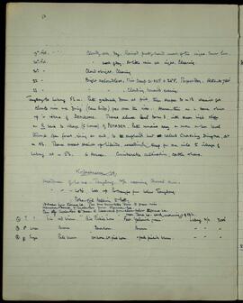
Daily weather notes for 19–23 Feb are followed by a detailed route from Tangdong to Lubong via Domuong, Pemadem, and Chashing Dingka, with altitude and terrain described. Photographic and field notes mention a headman of lower Tangdong, a Poba girl talking to Betty, panoramas from Karma La toward Namcha Barwa and Gyala Peri, and bird observations at Lubong.

CONTENT:
50

19th Feb. Cloudy all day. Rained pretty hard most of the night. Snow low.
20th Feb. Most of day. A little rain at night. Clearing.
21st - Cloud at night. Clearing.
22nd - Bright and cloudless. Min temp 21-22° = 26°F. Perfect day. Altitude 7500'
23rd - " " . Clouding towards evening.

Tangdong to Lubong 5 1/2 m. Path gradually down at first, then steeper to m 1 1/2 where it gets close to river and a 'zhing' (cane bridge) goes over the river. Above this on L bank high up is village of DOMUONG. Thence almost level to m 3, with sheer high cliffs on R bank to village (5 houses) of PEMADEM. Path remains easy and more or less level through open forest, rising at end, to a shepherd's hut called Chashing Dingka, at m 4 1/2. Thence ascent straight up hillside, exceedingly steep for one mile to village of Lubong at m 5 1/2. 6 Houses. Considerable cultivation, cattle there.

Kodachrome 14.
Headman of lower Tangdong. 20/2 wearing Goral skin.
-- Loto, look up Tsangpo from below Tangdong.
-- Poba girl talking to Betty.
Upstream from Karma La. Pan from snow hills down to green river.
Namcha Barwa & Gyala Peri from Karma La.
Pan from Gyala Peri & peaks to westward from close below Karma La.
near Tana La. early morning // of 23/2.

(2) ? ? Iris red brown. Bill pinkish horn. Feet yellowish green. Lubong 21/2 7000'
(3) ♂ Wren Brown Dark horn. Brown - - -
(4) ♀ Sunya Pale brown UM horn. LM pink horn. v pale pinkish brown. - - -

LSH/1/1/8/1/24 · Part · 1946-12-11
Part of The Ludlow & Sherriff Collection

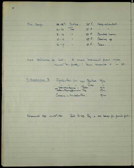
SUMMARY:
The page records minimum temperatures for successive nights around Shoka and Tse, notes a seed collection of Androsace, and lists Kodachrome photo subjects including Gyala Peri, Namcha Barwa, Tsela, and a crossing below Tse. Mohammed left on the 15th December with wages paid and money for ponies' food.

CONTENT:
Min. temp -
11-12th Shoka. 30° F. Half clouded.
12-13 Tse 31° F. Half clouded.
13-14 Tse 35° F. Clouded heavy.
15-16 Tse 19° F. Clearing up.
16-17 Tse 13° F. Clear.

12013 Androsace sp seed. A small branched plant, which should be pretty. I don't remember it in 38.

Kodachrome 8
Gyala Peri from near Shoka 12/12
Gyala Peri from near Paka 12/12
Namcha Barwa - Tsela - 13/12
Tsela Dzungpon and Tse 15/12.
Crossing in Tru below Tse. 18/12

Mohammed left on 15th Dec. Paid Rs 20/- Pay + 200 sangs for ponies' food.

LSH/1/1/9/1/89 · Part · 1933-06-11
Part of The Ludlow & Sherriff Collection

SUMMARY:
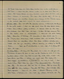
The diarist reflects on rainfall patterns across SE Tibet and suggests a rain-gauge transect from Sikkim to the Tsangpo Gorge. On 30 June heavy rain hampers collecting, with Meconopsis bella absent and only M. simplicifolia common; seed of P. atrodentata is ripe, and plans are made to try Marlung, Waitang, and Trompa-lun. On 1 July, despite very wet conditions, the diarist and one Bhutanese assistant go via the Chachhu La to a large high-altitude lake.

CONTENT:
the south side here, are lower than similar ones on the north side in SE Tibet. I can't see the reason, unless it be that rain does not reach the main range in any amount until about the first week in June, whereas it certainly does before that further east. A line of rain gauges at similar heights from Sikkim to the Tsangpo Gorge, on the actual rain axis would be most interesting.

30th June. Halt. Rain most of the day, especially morning. A thoroughly bad day for the last of the month. I went out round over the cliffs opposite camp & came back without getting a flower. It seemed ideal for Mec. bella for instance, but there was no sign. In fact the only common Mec. in this whole area is simplicifolia. I hope we will find Marlung better than here or Waitang. At any rate I plan to get over to the Trompa-lun somehow, & feel confident that will be better. But one cannot find out anything about these places without actually going. Locals will tell you anything without knowing, or nothing if they do know. Seed of P. atrodentata is now ripe. It is always the first to ripen.

1st July. Halt. A very wet day indeed, but I went out with just one Bhutanese to carry the press, & went up the Chachhu La route to a very big lake about 15000'. We had a good day on the whole, & had I only been living up there, I believe we would have done really well. Saw masses of

Weale, James A.
GB 235 WEA · Item · 2015

•Catalogue of Micrographs of woods structure

Weale, James A.
Watsonby, Hewett
GB 235 WYH · Item · 1871

•Letter to from J. Newman from to H. Watsonby (14 Feb 1871)

Watsonby, Hewett